Share
Department of Regional Planning and Development
Office of Geographic Information Systems (GIS)
Office of Geographic Information Systems (GIS)
Ranae Fehr, Department Head
P.O. Box 719
Rt. 9 and Dolphin Ave.
Northfield, NJ 08225
Phone: (609) 645-5898
Fax: (609) 645-5836
Questions/Comments?
Email the Public Information Officer - pio@atlantic-county.org
or use our contact form.
Census 2000
 The Community Development Block Grant Program (CDBG) requires that each activity
must principally benefit low- and moderate income persons in order to be funded from CDBG funds. The easiest way to determine this, which is acceptable to HUD, is to use the census information that they provide to determine the
income characteristics of the beneficiaries within the service area of a particular project.
The Community Development Block Grant Program (CDBG) requires that each activity
must principally benefit low- and moderate income persons in order to be funded from CDBG funds. The easiest way to determine this, which is acceptable to HUD, is to use the census information that they provide to determine the
income characteristics of the beneficiaries within the service area of a particular project.
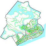
HUD has also made a determination that Atlantic County is an "exception grantee" and that the minimum percentage of low and moderate income persons that must reside in the service area for a project to qualify is 45.1%. The smallest area that they will accept is a "block group". The maps identify each block group in each municipality. Those block groups that contain at least 45.1% low-mod residents (total Low/Mod persons divided by the Low/Mod universe information provided by HUD) are highlighted in purple.
When the municipalities and their engineers are identifying potential projects and we are qualifying them, the maps provide a visualization that is invaluable. If the beneficiaries within the service area meet the 45.1%, the project is eligible for funding. Each project file must contain documentation that identifies how that determination was made. If the determination was made based on the census info, copies of the maps are included.